Written by Fred Harmon - October 13, 2005
More photos of this unit can be found here:
http://www.pbase.com/fredharmon/garmin376c
So you dont like to ride in the rain. Neither do I. And I find it increasingly harder and harder to find a good television news station that displays the weather radar images for more than a few brief seconds before they change to a commercial. For several years now I have been saying If only I could have a weather radar image displayed on my GPS.
Well, now the only question seems to be, how much are you willing to pay to have it? Would you be willing to cough up roughly $1,000 for the GPS and software and memory cards and then pay another $30 a month for the weather data? If so, read on. If not, you probably should stop now, because if you continue reading this you may develop the dreaded GPS-Envy syndrome.
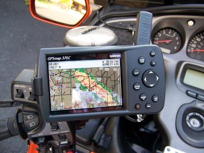
Here is the GPS mounted on the bike
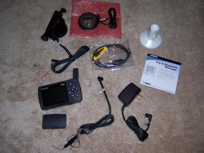
 Lets start by discussing the cost of all this and get that out of the way. I purchased my GPS from http://www.getfeetwet.com for $770. They have good service and about the best prices I could find, and I would highly recommend them. In addition to the GPS you will also probably want the Garmin City Select software and a data cartridge. The software costs roughly $120 and a 128mb cartridge is $70 and a 256mb cartridge is $100. The software and data cartridge allow you to load more detailed maps and points of interests (hotels, restaurants, gas stations etc) into the unit. The unit has an internal base map that covers all major roads and highways, but for motorcycle travel it is nice to have the smaller roads and streets loaded into the unit from the City Select software. They also offer a Auto Navigation kit package ($205) that includes the City Select software, a data cartridge, an Auto mount, and a cigarette lighter adapter with built in speaker all bundled together. If you think you ever might use the GPS in your car, this is probably the way to go, as the bundled kit will save you some dollars. So for $770 plus $205 for the Auto Nav kit, you are ready to go, almost. In order to get the weather information, you will have to subscribe to the XM Radio weather package for a minimum of $30 plus a one time activation fee of $50. Ok, now we are up to $1,055 including the first month of service.
To date, I have owned 7 different Garmin GPS units, dating all the way back to the GPS III in the mid 90's, and this is by far the most expensive one. It also is the most useful one I have owned and has the most features.
GPS with XM Antenna on supplied marine mount

Are you still with me? Ok, now on to the meat of the review. Let me state right up front, that the 376C is designed mainly as a Marine GPS but also has Automotive functions. It has many Marine functions that will go unused on land, but so far it is the only portable unit Garmin (or anyone else I know of) offers that has the weather data package. It also has a LCD screen that is easily visible even in direct/bright sunlight, and it has an internal rechargeable Lithium-Ion battery. These features make it highly suitable for use on a motorcycle. If you are familiar with the Garmin Streetpilot series of GPS units, you will note that the screen on them becomes hard to see in direct sunlight, and the newer models also do not have any internal battery so they can not be used unless plugged into power. The bigger/brighter screen and battery opeation are just two of the reasons I personally prefer the Marine 267C and 376C over the Streetpilot models. The 276C and 376C also have several features and options that are not available on the Streetpilot series.
The 376c is almost exactly the same GPS as the 276c with the weather data added. There is a very thorough review of the 276C GPS posted here if you want to know more about it and it should also apply to the 376c.
http://www.gpsinformation.org/wilson/g276crev.htm
I will not go into all the features and menus and options of the 376 because it would simply take too much time and I could not do it justice. I suggest you read the above review to find out more about how the unit operates. This review will mainly center on the weather data operation and how it works. Ok, lets get on with it then.
First let me briefly touch on the features of the 376C. It is a 12 channel WAAS (Wide Area Augmentation System) enabled chartplotter/car navigator GPS capable of both Auto Routing and Voice Navigation. The route calculation is significantly faster on both the 276 and 376 than previous models. The 376C has the ability to generate track logs, and to track-back and to show celestial and tide data. It can also be hooked up to Sonar on a boat and has Digital Select Calling features for marine VHF when in the marine mode. It has configurable system alarms for things like voltage and alarm times as well as alarms for approaching tornados or thunderstorms and flood events. The 376C even has a calendar built in and can show when the next full moon is, and predict good times for hunting and fishing. All the screens are configurable to display the amount, position and type of data you want, and I find this a highly useful feature. System voltage can be displayed which allow you to use the GPS as a voltmeter for your motorcycle when it is powered off the bike, and you can even program it to set off an alarm when the voltage drops below whatever level you tell it to. Sunrise, sunset, elevation, time, speed, distance odometers, ETA, and a long list of other data are able to be displayed on the various pages. The list goes on and on.
Enough about all that already, lets talk about the weather info, after all, that is why you are reading this review, right?
There are three weather data packages that you can subscribe to for this unit, the Fisherman, the Sailor, and the Master Mariner.XM Package Info The Fisherman and Sailor package cost $30 a month and the Master Mariner costs $50 a month. The main differences I noticed are that the Fisherman gives you surface pressure, snd the Sailor gives you surface wind speeds and directions, while the Master Mariner gives you both in addition to a Satellite mosaic that shows cloud cover. Other options like wave speed and direction and wave height/period, hurricane track, buoy data and other marine data are also included in the various packages. You can also easily switch between packages at any time and XM will pro-rate your monthly fee. This allows you to upgrade to the Master Mariner package while you travel and drop back to the less expensive package when you return, and you will only pay the higher rate for the time that you used it.
The weather info ultimately comes from the National Weather Service. It is provided to XM through a company called WxWorxs http://www.wxworx.com and is received by the 376C by the external hockey puck shaped XM antenna. This antenna plugs into the 376C via the USB port that you also use to download map data from your PC. The bottom of the XM antenna has a magnetic base that makes it easy to attach to any metal object, and I was able to fabricate a bracket that allowed me to attach this antenna to the GPS mount itself. The GPS antenna for the 376C is identical to the 276C and is attached to the back of the unit itself.
There is a wide variety of weather info sent to the unit other than just the NEXRAD radar images, and they all update at different time intervals. The NEXRAD data is updated on a 5 minute cycle and storm cells are updated every 1.25 minutes. On the other end of the spectrum, the Satellite Mosaic updates every 15 minutes and the Marine Warnings update every 20 minutes.
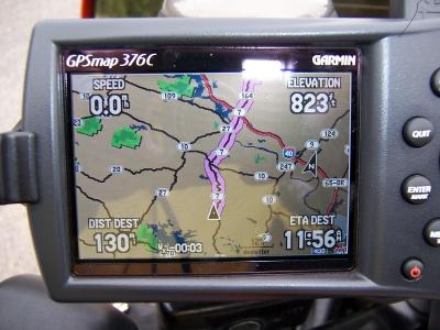
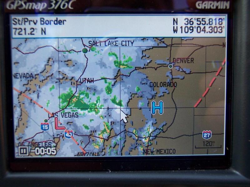
Dodging storms while navigating a route in Arkansas
 Another thing to keep in mind is that the accuracy of the system is only as good as the data it receives. It is not unusual for ground clutter to show up around the NEXTRAD sites, and I have also seen ghost rain cells show on the NEXRAD that were not really there. Timeliness is also an issue, as the data may already be 5 or more minutes old once it is displayed, and if it is a fast moving storm you may actually feel the rain before it shows up on your screen.
But for the most part, the NEXRAD images are highly accurate and timely and will provide you with everything you need to be able to avoid a storm or take shelter before it arrives. Or at the very least, pull off and get your rain gear on before you actually start getting wet. My purpose for getting the unit was so I can see where the storm and rain cells are and re-route myself around them. So far that strategy seems to be working.
Another thing to keep in mind is that the accuracy of the system is only as good as the data it receives. It is not unusual for ground clutter to show up around the NEXTRAD sites, and I have also seen ghost rain cells show on the NEXRAD that were not really there. Timeliness is also an issue, as the data may already be 5 or more minutes old once it is displayed, and if it is a fast moving storm you may actually feel the rain before it shows up on your screen.
But for the most part, the NEXRAD images are highly accurate and timely and will provide you with everything you need to be able to avoid a storm or take shelter before it arrives. Or at the very least, pull off and get your rain gear on before you actually start getting wet. My purpose for getting the unit was so I can see where the storm and rain cells are and re-route myself around them. So far that strategy seems to be working.
The 376C also has the ability to animate the radar images. The unit stores the past 4 images in memory along with the time that they were recorded, and then plays them back showing storm direction and speed. The time is displayed as a negative number that shows how many minutes old each image is. So for example, as it animates a storm, you might see -21, -16, -11, and -5 displayed in the lower left corner as the images load. And at the next update cycle the oldest image will drop off and the most recent will be displayed.
Map Set Up page
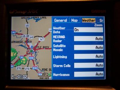
You also have the ability to hide the NEXTRAD and weather related data so it does not show on the map screen. The unit can also display front lines and county warning boxes on the map if you wish to see them. There is Weather Page on the main menu that allows you to look at the various weather images and scroll through them. This page can also show you forecast maps up to 48 hours in advance.
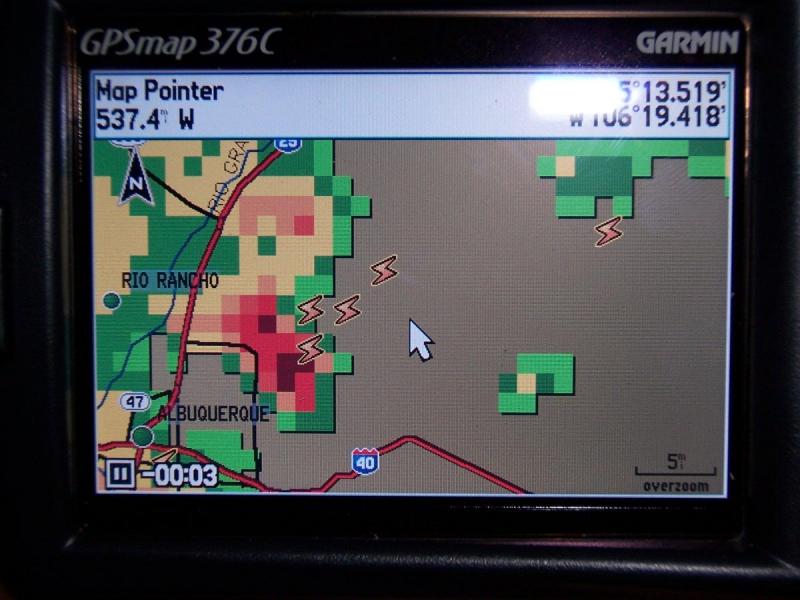
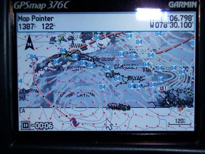
By placing the cursor on a storm, you can see the type/amount of precip
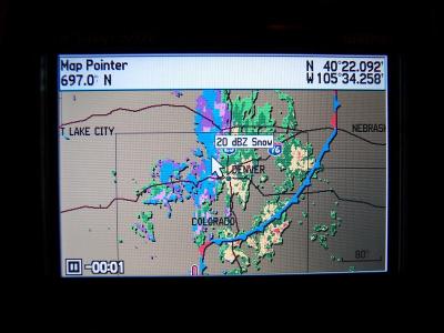
The NEXTRAD is probably the most useful of the all the weather info and allows you to see at a glance what weather lies in your path or intended route so you can make informed decisions about what to do. You can also scroll the cursor over any area of the US and zoom in on any weather cell you are interested in.
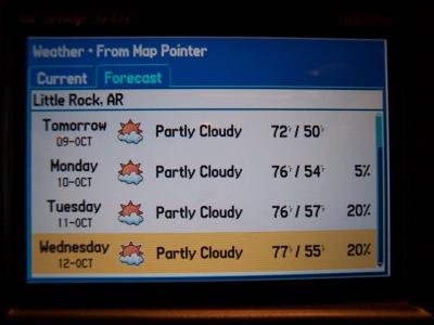 There are other features to the weather information that are worth mentioning as well. On the Garmin 276C you can scroll the cursor over any city and hit the FIND button and bring up a list of Hotels, restaurants, gas stations as well as their phone numbers to call ahead and make a reservation. Many times I have found this a very useful feature. This feature remains on the 376C and now another menu option has been added. You can now find the current weather conditions as well as a 5 day forecast for any area in the US by simply positioning the cursor over that area and selecting FIND and then WEATHER DATA. This will bring up the data from the closest weather station including Wind, Visibility, Relative Humidity, Dew Point, Pressure, Current/High/Low temperatures, and Ceiling. In essence, you have a portable weather center that has access to data for the entire US right at your disposal. Who needs the weatherman with this thing around!
UPDATE Nov 14, 2005
I would be remiss if I did not include this in my review. After three weeks of use, I experienced a problem with my 376 that started with a "XM Antenna not responding" message. The unit then began intermittently turning off the back light, and locking up. Fortunately, the folks where I bought the unit from http://www.getfeetwet.com were gracious enough to let me return the unit to them for in exchange for a brand new one. Obviously I could have returned it to Garmin for repair, but this was faster and easier for me. I also forgot to mention that by purchasing the unit from GetFeetWet, they automatically extended my original warranty from one year to two years. Good customer service like this is hard to come by these days, and coupled with the excellent price, I highly recommend them.
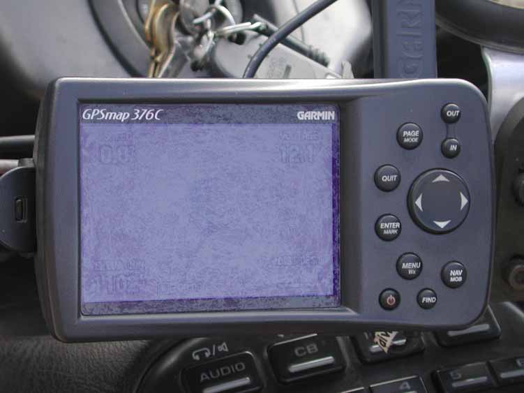
Also, I have noticed a problem with the screen on the 376c. Under certain circumstances, it can be a bit hard to read when it is in the automotive mode and being used outdoors in warmer temperatures. The screen seems to darken a shade or two when the unit heats up, like when it is left sitting in the sun. The background color for land in the automotive mode is a shade of brown, and this does not make for good contrast against the roads that show up as black lines. It appears to be a combination of poor choice of colors for contrast, and the screen darkening in the sun when the unit warms up, but the end result is that the screen can be hard to read under indirect or off angle sunlight in warmer temps with the unit in the automotive mode. I suspect this problem could be easily fixed if the background color was set to a lighter shade that provided more contrast, and maybe Garmin could do this through a simple firmware upgrade.
UPDATE Aug 22, 2006
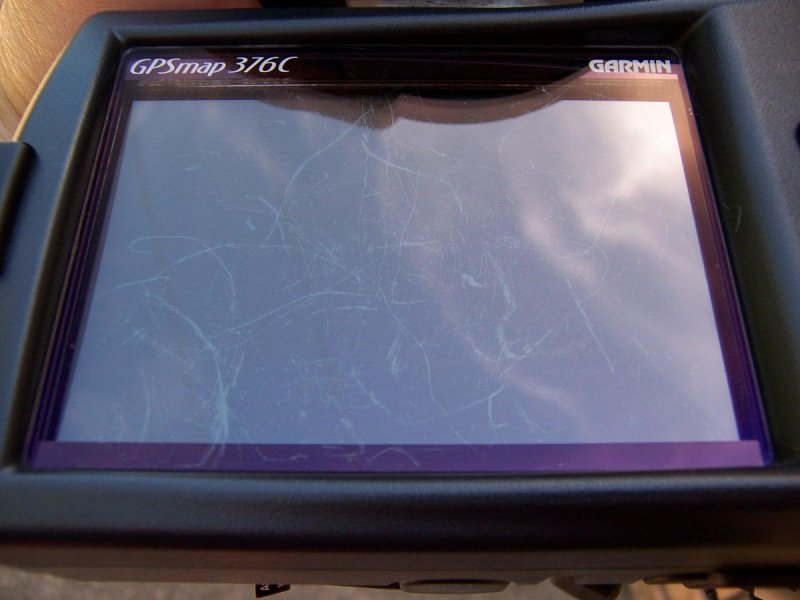
The replacement unit I received after having an initial antenna failure has worked flawlessly, and I continue to be highly impressed with the features of the 376c. However, I began having problems with the screen becoming scratched, despite only cleaning it with lint free cotton cloths and no chemicals. The screen coating on the surface of the 376c appears to be extremely fragile and I have seen at least 6 other units now that have suffered from the same problem. I recently had to return the unit to Garmin for replacement, and while they took care of it without any issues, I fear what will happen when the warranty runs out. I have seen 2 other 376c's that the screen coating has actually delaminated from the surface slightly making the screen unreadable, and all of them I have looked at have shown scratches after only a few days of use. I now have a PDA cover on my screen to protect it, but this causes glare and blurs the image some, so it really is not an ideal solution. Oddly enough, none of the 276c units seem to suffer from this problem, so I suspect Garmin changed something in the coatings on the 376c.
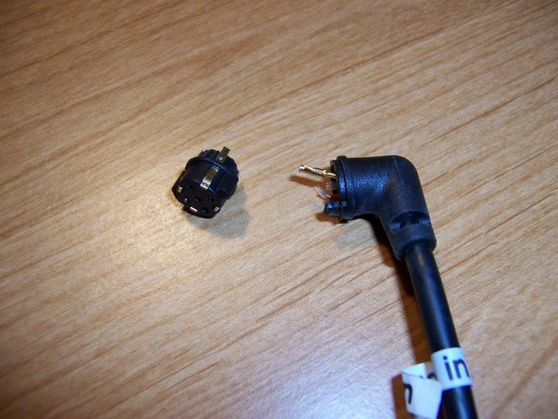
Another item I have had numerous problems with is the connector on the power cord. It snaps in so tightly that it makes it extremly hard to remove and after you remove it a few times, the connector starts to pull out of it's body. Garmin has been good about replacing them, but I am now on my 8th one, and it just failed again. Something needs to be done to redesign this connector so it doesn't snap in so tightly or else so it doesn't pull apart.
The beginings of screen crazing/scratching on a 376c screen can be seen here in this photo. This is how it starts and then it gets worse
Here is another example of a unit after less than one years time
Yet another broken power connector. I think this makes number 9.
Satellite Mosaic view shows cloud cover ($50 Master Mariner Package)
Lightning Data ($50 Master Mariner Package)
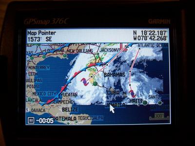
Hurrican Track (Wilma) in Marine Mode
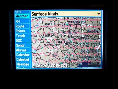
Wind Speed and Direction
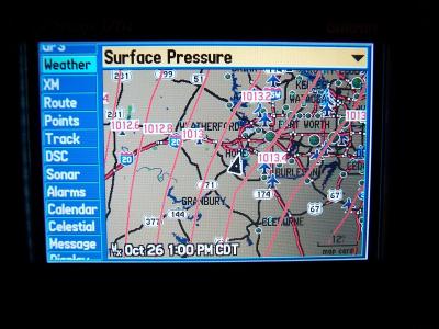
Barometric Surface Pressure

(Just kidding)